Incident Information Panel Fields
The Incident Information panel shows address information associated with the incident.
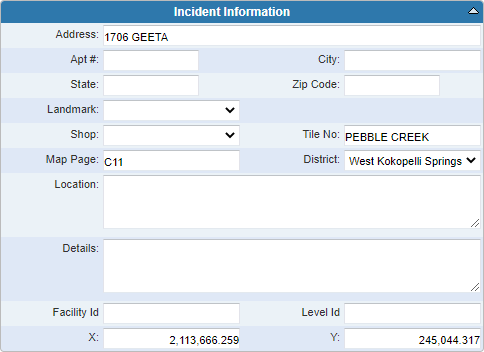
- Address: Enter the address.
- Apt #: Enter the apartment number.
- City: Enter the city.
- State: Enter the state.
- Zip Code: Enter the zip code.
- Landmark: Select the landmark from the drop-down list. The contents of this drop-down list are populated by the administrator in Designer under Preferences > Custom Codes > LANDMARK. If it is blank, that means the administrator has not entered any landmarks. See Configure Custom Codes Preferences in the Designer for 15.8 Guide for more information.
- Shop: Select the shop from the drop-down list. This field is populated in Designer under Preferences > Map > Shop Values. If it is blank, that means the administrator has not entered any shops. See Configure Map Preferences in the Designer for 15.8 Guide for more information.
- Tile No: Enter the tile number. This field is used to indicate the geographic area of the incident.
- Map Page: Enter the map page. This field is used to indicate the geographic area of the incident.
- District: Select the district from the drop-down list. Districts can represent any geographical area and are populated in Designer under Preferences > Map > District Values. If this field is blank, that means the administrator has not entered any districts. See Configure Map Preferences in the Designer for 15.8 Guide for more information.
- Location: Enter any additional details about the location of the incident that help to identify it (for example, Northwest corner of the intersection).
- Details: Enter any details.
-
Facility Id: Enter the Facility ID for the building where the incident occurred. This corresponds with the facility and level IDs set up for assets in the geodatabase. See
-
Level Id: Enter the Level ID for the floor level where the incident occurred. This corresponds with the facility and level IDs set up for assets in the geodatabase. See
-
X/Y: The X and Y coordinates automatically populate when the address is geocoded.

